Behbahan
City in Khuzestan province, Iran
City in Khuzestan, Iran
Behbahan Persian: بهبهان | |
|---|---|
City | |
 Ring of Power, the historical symbol of Behbahan | |
| 30°35′39″N 50°14′36″E / 30.59417°N 50.24333°E / 30.59417; 50.24333[1] | |
| Country | Iran |
| Province | Khuzestan |
| County | Behbahan |
| District | Central |
| Population (2016)[2] | |
| • Total | 122,604 |
| Time zone | UTC+3:30 (IRST) |
Behbahan (Persian: بهبهان)[a] is a city in the Central District of Behbahan County, Khuzestan province, Iran, serving as capital of both the county and the district.[4]
At the 2006 National Census, its population was 99,204 in 24,204 households.[5] The following census in 2011 counted 107,412 people in 29,280 households.[6] The latest census in 2016 showed a population of 122,604 people in 35,826 households.[2]
Etymology
The origin of word 'Behbahan' can be traced back to two distinct ideas. According to some scholars like Nowban[7], while the first part of the word, 'beh', means 'good', the latter, 'bahan', means palace or a very big house surrounded by orchards and gardens. This is well-documented that the region was an agricultural center/hub producing mainly olive, dates, citruses as well as flower gardens[8][9]. This means, the term Behbahan means a nice living area surrounded by gardens & farms.
Alternatively, it is suggested that the latter component of the word, namely 'bahan', might had been used to refer to a type of tent used in old times. In other words, after the downfall[10] of the ancient city of Arrajan due to a series of devastating earthquakes[11], survivors unsurprisingly had to live in tents for some time. As they started to reconstruct the city, the name 'Behbahan' was used to mean it is better than tents.[12] However, the use of the word 'beh' as 'better' rather than 'good' is rarely, if any, reported in Persian langauge[13]. Also, there is no actual document of people using 'bahan' tents after the above-mentioned earthquakes. Resultantly, there needs to be more research on the etymology of the word Behbahan.
History of Behbahan

The city was established by the Sasanian king Kavadh I (r. 484, 488–497 and 499–531), who in his third period of his rule launched a campaign as part of the Anastasian War against northern Roman Mesopotamia, and deported 80,000 prisoners from Amida, Theodosiopolis, and possibly Martyropolis to Pars and Khuzestan provinces, some of whom are thought to have built the city of Arrajan. The people of the Amida region were experts in linen production, and Arrajan quickly became a center of this product.
Gallery
-
 A replica of Arjan bowl
 -
 Ring of Power Statue, Symbol of Ancient Behbahan (Arjan Square)
 -
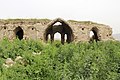
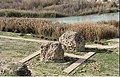 Ruins of Arjan Briges on Marun River in Northern Behbahan
 -
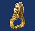 Arjan Ring of Power from Elamite king Kidin-Hutran
 -

-
-
 Marun Dam Public Resort
 -
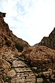
 An outpost from Sassanid Era near Borj village, Behbahan
 -
 Main souvenir of Behbahan, daffodils
 -
 Bowl of Arjan
 -
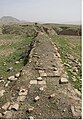 Ruins of Arjan town walls in northern Behbahan
 -
 1950s map of Behbahan
 -
 Ruins of a Nestorian church in Tashan village, Behbahan


Climate
Behbahan has a hot semi-arid climate (Köppen: BSh), characterised by sweltering and rainless summers and pleasant winters with occasional heavy rainfall.
| Climate data for Behbahan (1991-2021) | |||||||||||||
|---|---|---|---|---|---|---|---|---|---|---|---|---|---|
| Month | Jan | Feb | Mar | Apr | May | Jun | Jul | Aug | Sep | Oct | Nov | Dec | Year |
| Mean daily maximum °C (°F) | 16.7 (62.1) | 18.9 (66.0) | 24.4 (75.9) | 30.5 (86.9) | 38.2 (100.8) | 42.9 (109.2) | 44.3 (111.7) | 44.1 (111.4) | 40.3 (104.5) | 34.6 (94.3) | 24.2 (75.6) | 18.5 (65.3) | 31.5 (88.6) |
| Mean daily minimum °C (°F) | 6.0 (42.8) | 7.2 (45.0) | 10.5 (50.9) | 15.5 (59.9) | 21.1 (70.0) | 25.4 (77.7) | 28.2 (82.8) | 27.9 (82.2) | 23.9 (75.0) | 19.2 (66.6) | 12.6 (54.7) | 7.9 (46.2) | 17.1 (62.8) |
| Average rainfall mm (inches) | 117 (4.6) | 75 (3.0) | 69 (2.7) | 28 (1.1) | 6 (0.2) | 0 (0) | 0 (0) | 1 (0.0) | 1 (0.0) | 5 (0.2) | 74 (2.9) | 116 (4.6) | 492 (19.3) |
| Source: Climate-data.org | |||||||||||||
See also
 Iran portal

Notes
References
- ^ OpenStreetMap contributors (27 July 2023). "Behbahan, Behbahan County" (Map). OpenStreetMap. Retrieved 27 July 2023.
- ^ a b "Census of the Islamic Republic of Iran, 1395 (2016)". AMAR (in Persian). The Statistical Center of Iran. p. 06. Archived from the original (Excel) on 21 October 2020. Retrieved 19 December 2022.
- ^ Behbahan can be found at GEOnet Names Server, at this link, by opening the Advanced Search box, entering "-3055917" in the "Unique Feature Id" form, and clicking on "Search Database".
- ^ Habibi, Hassan. "Approval of the organization and chain of citizenship of the elements and units of the national divisions of Khuzestan province, centered in the city of Ahvaz". Islamic Parliament Research Center (in Persian). Ministry of Interior, Political and Defense Commission of the Government Board. Archived from the original on 17 July 2014. Retrieved 25 January 2024.
- ^ "Census of the Islamic Republic of Iran, 1385 (2006)". AMAR (in Persian). The Statistical Center of Iran. p. 06. Archived from the original (Excel) on 20 September 2011. Retrieved 25 September 2022.
- ^ "Census of the Islamic Republic of Iran, 1390 (2011)". Syracuse University (in Persian). The Statistical Center of Iran. p. 06. Archived from the original (Excel) on 18 January 2023. Retrieved 19 December 2022.
- ^ Nowban, Mehrozaman (1998). Names of Geographical Places across Time (in Persian). Mah. p. 118. ISBN 964-6497-00-4.
- ^ Qubadiani-Balkhi, Naser Khosrow (2007). Vazinpour, Nader (ed.). Book of Travels (in Persian) (10th ed.). Tehran: Amirkabir.
- ^ "گنجور » ناصرخسرو » سفرنامه » بخش ۹۲ - ارجان". ganjoor.net. Retrieved 31 May 2024.
- ^ Iranica Encyclopedia. "Arrjan". Encyclopedia Iranica. Retrieved 31 May 2024.
- ^ Ebn-e Athir, Ezzoddin (2005). The Full History (in Persian). Translated by Roohani, Hossein (3rd ed.). Tehran: Asatir.
- ^ "Meaning of Behbahan - معنى بهبهان". 14 July 2011. Archived from the original on 14 July 2011. Retrieved 6 February 2021.
- ^ Dehkhoda, Ali Akbar (2007). Dehkhoda Dictionary of Persian Language (in Persian). Tehran: Tehran University Publications. ISBN 964-0393851.
External links
- The Marafi (Behbahani) Family of Kuwait
- Behbahani dialect profile
- v
- t
- e
Khuzestan Province, Iran

and cities
- Abadan's museum
- Gundishapur
- Acropole of Shush
- Apadana in Susa
- Arjan castle, Behbahan
- Asak ancient city, Hendijan
- Chagadom tappe fire temple
- Chogha Mish Proto-Elamite site
- Chogha Zanbil
- Dav o Dokhtar castle, Ramhormoz
- Dez Dam
- Eshkaft-e Salman
- Gargar bridge, Shushtar
- Haft Tepe
- Hoor-al-azim lagoon
- Imamzadeh Roudband, Dezful
- Imamzadeh Sabz-e-ghaba, Dezful
- Karkheh Dam
- Khorramshahr mosque, Battle of Khorramshahr
- Kul-e Farah
- lake of Karkheh dam
- Lake of Karun
- Lali bridge
- Meyangaran lagoon
- Rangooni's mosque
- Salasel castle, Shushtar
- Shadegan lagoon
- Shevi waterfall, Dezful
- Shush-Daniel
- Shushtar Historical Hydraulic System
- Shushtar Watermills
- Susa
- Shush Castle
- Taryana
- Tobiron valley, Dezful
- Tomb of Daniel, Shush
- White bridge, Ahvaz
- Ya'qub-i Laith's tomb, Dezful


