César Chávez Park
City park of Berkeley, California
37°52′21″N 122°19′10″W / 37.87241°N 122.31942°W / 37.87241; -122.31942

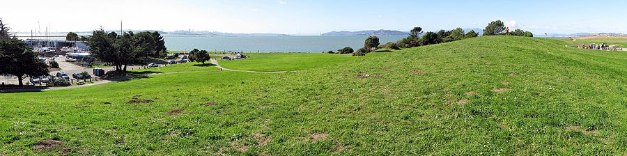
César Chávez Park is a 90 acres (36 ha) city park of Berkeley, California named after César Chávez.[1] It can be found on the peninsula on the north side of the Berkeley Marina in the San Francisco Bay and is adjacent to Eastshore State Park.
The park's east position in San Francisco Bay provides panoramic views of San Francisco, the Golden Gate Bridge, the Marin Headlands, and the East Bay hills. The park's terrain is characterized by very open grassy hills that have become popular for kite flying.[2] Paved paths run the perimeter and throughout the park where picnic tables and barbecue grills are available to the public.
Features
- Grassy areas for kite flying, "Frisbee" playing, etc. (no officially designated sports fields).
- Hiking on trails throughout the park; the 1.25-mile (2.01 km) Dorothy Stegmann trail around the park's perimeter is fully wheelchair accessible.
- Off-leash dog area (17 acres [6.9 ha]).
- Picnic tables with BBQ grills (several arranged for large groups).
- Solar Calendar.
- Wildlife sanctuary.
- The park's traditional public washroom was closed in 2015, but, in 2019, City Council considered replacing it with a more robust Portland Loo.[3]
History
The park began as a landfill dating back to 1957, when dikes were constructed for the purpose of containing municipal waste. In 1969, the city adopted the Marina Master Plan, which set aside the landfill area for unstructured recreation. In 1991 the city completely sealed the landfill and the park opened soon thereafter, originally as North Waterfront Park. In 1996, the city renamed the park after César E. Chávez, union leader and founder of the United Farm Workers of America.[1]
Landfill gas
A landfill gas flare station lies on the eastern side of the park. Decomposition of the garbage below emits gases, primarily methane. To prevent its uncontrolled seepage from the ground, the gas is collected by over 40 extraction wells buried throughout the park and routed to the flare station, which then de-waters and burns it at over 1,470 °F (800 °C), converting approximately 99% of the collected methane into carbon dioxide.[4] Though both methane and carbon dioxide are greenhouse gases that contribute to the ongoing climate crisis, the conversion of methane to CO2 reduces its heat-trapping effectiveness by a factor of 25.[5]
A 1990 study reported low levels of methane seepage from the underlying waste and attributed the absence of gases to rapid oxidation by soil microorganisms.[6] As an alternative to the incinerator, local activists proposed to leverage the effect as a bioremediation method. The proposal was rejected by the Bay Area Air Quality Management District due to its experimental nature.[4]
In 2016, the waning flow of gas was unable to properly sustain the existing flare station, leading to problems including visible smoke, flames, and odor emanating from the chimney.[7] As a result, the original incinerator, which was built in 1989, was replaced with a newer, smaller model better designed to be sustained by the lesser supply of fuel.[8]
Activities
Popular activities include model rocket launching, kite flying, drone and model airplane flying, picnicking, dog walking, jogging and walking. Although on a peninsula, the park has no access to the water because there are no beaches nor steps down through the park's reinforced shoreline.[1]
Events

- Solstice and Equinox celebrations at the Solar Calendar: Celebrations are held quarterly on the solstices and equinoxes. These celebrations include both scientific and cultural components. From the web site: "Many cultural celebrations are rooted in the cycles of the sun and moon, especially the solstices and equinoxes. For example, Easter, Passover, Narooz in the Spring, Rosh Hashanah, Kwanzaa, Christmas in the winter, etc."[9]
- Fourth of July Celebration and Fireworks: While most of this event is held elsewhere in the Marina, many people gather on the small hills at Cesar Chavez Park to watch the fireworks.
- Berkeley Kite Festival: Annual event held the last weekend in July. Hundreds of kites of all sizes are flown by amateurs and professionals. Thousands of people attend, making parking difficult.[10]
References
- ^ a b c Berkeley Department of Parks, Recreation & Waterfront Archived 2009-08-04 at the Wayback Machine
- ^ "Berkeley Kite Festival". The City of Berkeley. Archived from the original on 2007-10-15. Retrieved 2007-10-24.
- ^ Theresa Clift (2019-02-04). "'Civic responsibility' or crime magnet? Historic Sacramento park likely to get public bathroom". Sacramento Bee. Retrieved 2019-02-05.
The City Council will soon consider whether to approve the design and construction of a restroom in the park for $360,000. The "Portland Loo" style freestanding restroom would not just serve the homeless who congregate there but also the general public, said Councilman Steve Hansen, who represents downtown.
- ^ a b Nicolaus, Martin. "The Landfill Gas Flare Station". Chavez Park Conservancy.
- ^ "Importance of Methane". epa.gov.
- ^ Whalen, S.C.; Reeburgh, W.S.; Sandbeck, K.A. (August 1990). "Rapid Methane Oxidation in a Landfill Cover Soil". Applied and Environmental Microbiology. 56 (11): 3405–3411. doi:10.1128/aem.56.11.3405-3411.1990. PMC 184961. PMID 16348346.
- ^ "Flare Station Malfunction Spews Flames, Smoke, Stink". chavezpark.org.
- ^ "Flare station is replaced at Berkeley's Cesar Chavez Park". berkeleyside.org.
- ^ "Solar Calendars & The Rhythm of the Seasons". The Solar Calendar. 2010. Archived from the original on 9 September 2012. Retrieved 1 November 2010.
- ^ "Berkeley Kite Festival". Hghline Kites. 2010. Retrieved 26 November 2010.
External links
 San Francisco Bay Area portal

- César E. Chávez Park - City of Berkeley
- The Solar Calendar: A César E. Chávez Memorial - located on a hill on the west side of the park.
37°52′21″N 122°19′10″W / 37.87241°N 122.31942°W / 37.87241; -122.31942
- v
- t
- e

- Major
- San Francisco Bay
- Suisun Bay
- San Pablo Bay
- Minor
- Golden Gate
- Grizzly Bay
- Richardson Bay
- San Rafael Bay
- Richmond Inner Harbor
- San Leandro Bay
- Former
- Yerba Buena Cove
- Mission Bay
- Rivers
- San Joaquin
- Sacramento
- Napa
- Guadalupe
- Petaluma
- Creeks (discharging into the Bay)
- Alameda
- Baxter
- Cerrito
- Codornices
- Coyote (Santa Clara)
- Coyote (Marin)
- San Leandro
- San Lorenzo
- Schoolhouse
- Temescal
- Sausal
- Redwood
- San Mateo
- Sonoma
- Corte Madera
- Arroyo Corte Madera del Presidio
- San Rafael
- Miller
- Novato
- Tolay
- San Francisquito
- Pacheco
- Alhambra
- Adobe
- Rodeo
- Refugio
- Pinole
- Garrity
- Rheem
- Karlson
- San Pablo
- Castro
- Wildcat
- Fluvius Innominatus
- Marin (Alameda County)
- Strawberry
- Easton
- Mission Creek
- Reservoirs
- Calaveras Reservoir
- Lafayette Reservoir
- Straits and estuaries
- Clifton Court Forebay
- Carquinez Strait
- Oakland Estuary
- Raccoon Strait
- Sacramento–San Joaquin River Delta
- Stockton Deepwater Shipping Channel
- Watersheds
- Laguna Creek Watershed
- Guadalupe watershed
protected areas
- Don Edwards National Wildlife Refuge
- San Pablo Bay National Wildlife Refuge
- Eden Landing Ecological Reserve
- Hayward Regional Shoreline
- Hayward Shoreline Interpretive Center
- Crown Memorial State Beach
- McLaughlin Eastshore State Park
- Emeryville Crescent State Marine Reserve
- Point Isabel Regional Shoreline
- César Chávez Park
- Brooks Island Regional Preserve
- Point Pinole Regional Shoreline
- Antioch Dunes National Wildlife Refuge
- Coyote Point Recreation Area
- Middle Harbor Shoreline Park
- National Estuarine Research Reserve
- China Camp State Park
- San Francisco Maritime National Historical Park
- SF Bay Trail
- Oyster Bay Regional Shoreline
- Big Break Regional Shoreline
- Palo Alto Baylands Nature Preserve
peninsulas
- Major islands
- Alameda
- Alcatraz
- Angel
- Treasure Island
- Yerba Buena
- Minor
- Brooks
- Bair
- Bay Farm
- Belvedere
- Brother
- Castro Rocks
- Coast Guard
- Greco
- Hooks Island
- Mare
- Red Rock
- The Sisters
- Marin Islands
- Roe
- Ryer
- Seal Islands
- Peninsulas/infill
- Albany Bulb
- Brisbane Baylands
- Point Isabel
- Foster City
- Fleming Point
- Hunters Point
- Sierra Point
- Steamboat Point
and tubes
marinas
- History
- Delta and Dawn
- Discovery Site
- Humphrey the Whale
- San Leandro Oyster Beds
- Richmond Shipyards
- U.S. Army Corps of Engineers Bay Model
- Harold Gilliam
- Marincello
- Ecology
- Golden Gate Biosphere Reserve
- Cosco Busan oil spill
- Thicktail chub
- Delta smelt
- Conservation and Development Commission
- The Watershed Project
- Save The Bay
- Citizens for East Shore Parks
- Friends of Five Creeks
- Urban Creeks Council
- 1971 oil spill
- Greenbelt Alliance
- The Bay Institute
- Reber Plan
- San Francisco Baykeeper
- San Francisco Estuary and Watershed Science
- Estuary Partnership
- Transportation
- Water Trail
- Transportation in the San Francisco Bay Area
 Portal
 Category


