Richmond Inner Harbor
Body of water in Richmond, California, United States
37°54′07″N 122°20′28″W / 37.9018697°N 122.3410816°W / 37.9018697; -122.3410816[1]
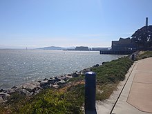
Richmond Inner Harbor is a deepwater body of water in Richmond, California.
History
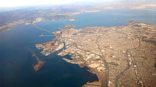
The harbor lies between Ferry Point and Point Isabel, between the mainland and Brooks Island in western Contra Costa County along the East Bay's northern East Shore. The harbor provides excellent protection as it lies protected by Brooks Island an extensive breakwater inside the already protected San Francisco Bay. The harbour connects to the Santa Fe Channel and its chanellets in addition to the Richmond Marina Bay and Campus Bay. Baxter Creek and Meeker Slough Creek's mouths and deltas drain into the harbor.
See also
- Richmond Shipyards
References
- ^ "GNIS Detail - Richmond Inner Harbor". Geographic Names Information System. United States Geological Survey. 19 January 1981. Retrieved 8 April 2010.
- v
- t
- e
- Rivers, creeks, streams: Baxter Creek
- Castro Creek
- Cerrito Creek
- Fluvius Innominatus
- Garrity Creek
- Meeker Slough (Creek)
- Rheem Creek
- San Pablo Creek
- Wildcat Creek
- Wetlands, Marshes, mud flats, swamps, sloughs: Albany Mudflats
- Breuner Marsh
- Brooks Island Salt Marsh
- Giant Marsh
- Hoffman Marsh
- Meeker Slough
- Parchester Marsh
- Point Molate Marsh
- San Pablo Creek Marsh
- Stege Marsh
- Whitell Marsh
- Wildcat Marsh
- Lakes, ponds, reservoirs, lagoons Brickyard Cove Pond
- Hilltop Lake (Hilltop)
- Temporary Pond
- Miller/Knox Lagoon
- Nicholl's Knob Pond
- North Reservoir
- Point Pinole Pond
- Potrero Hills Quarry Pond
- San Pablo Reservoir
- Bays, harbours, wharves, piers, ports, marinas, coves, channels: Brickyard Cove
- Campus Bay
- Castro Cove
- Harbor Channel
- Hoffman Channel
- Kozy Kove
- Lauritzen Canal
- Point San Pablo Marina
- Richmond Marina Bay
- Marina Bay Marina
- Parr-Rich Canal
- Port of Richmond
- Richmond Ferry Terminal
- Richmond Inner Harbor
- Richmond Outer Harbor
- Richmond Rod & Gun Club Yacht Harbor
- Richmond Yacht Club
- Santa Fe Canal
- Santa Rita Channel
- Santa Fe Marina
- San Pablo Canal
- San Francisco Bay
- San Pablo Bay
- Westshore Marina
- Landmasses, Rocks, Islands, Valleys, Canyons, Gorges, Points, Peaks, Beaches, Ranges: Berkeley Hills
- Brother Islands
- Brooks Island
- Castro Point
- Castro Rocks
- East Brother Lighthouse
- Ferry Point
- Kellar Beach
- Kozy Kove
- Richmond Long Wharf
- Nicholl's Knob
- Point Isabel
- Point Molate
- Point Pinole
- Point San Pablo
- Point Richmond Pier
- Point Pinole Pier
- Point Potrero
- San Pablo Canyon
- San Pablo Ridge
- Wildcat Canyon
| |||||||||||||
|---|---|---|---|---|---|---|---|---|---|---|---|---|---|
| Bodies of water |
|  | |||||||||||
| Counties | |||||||||||||
| Cities and towns |
| ||||||||||||
| CDPs over 10k | |||||||||||||
| Sub-regions | |||||||||||||
| Other | |||||||||||||


 | This Contra Costa County, California–related article is a stub. You can help Wikipedia by expanding it. |
- v
- t
- e


