Kærbygård
Danish manor house
| Kærbygård | |
|---|---|
 | |
 | |
| General information | |
| Architectural style | Half-timbered |
| Location | Harlev, Denmark |
| Completed | 1768 |
| Technical details | |
| Floor count | 2 |
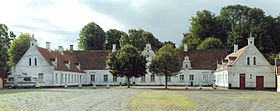
Kærbygård is a manor house and a listed building in Aarhus Municipality, Denmark. The manor was built in 1768 and was listed by the Danish Heritage Agency on 16 April 1990.[1] The estate has been an active farm since it was built.
The Kærbygård farm was moved to its present location north of Egå and the village of Kasted in 1680. In 1768 the original 3 winged half-timbered estate was built. In 1880 the facades facing the courtyard were renovated and rebuilt in brick, originally with exposed red bricks, but today whitewashed with neo-renaissance elements. In 1928 two parallel brick buildings for livestock were built in front of the manor building, held in yellow and red and with characteristic crow-stepped gables.[2]
References
External links
- "Fredede Bygninger Marts 2018" [Listed Buildings March 2018] (PDF) (in Danish). Danish Agency for Culture and Palaces. Archived (PDF) from the original on 3 March 2018. Retrieved 3 March 2018.
- v
- t
- e
- Aarhus Art Academy
- Aarhus Cathedral School
- Aarhus Central Workshops
- Aarhus City Hall
- Aarhus Custom House
- Aarhus Craftmen's Association's Asylum
- Aarhus State Gymnasium
- Aarhus School of Architecture
- Aarhus Theatre
- Badstuegade 1H
- Baumann House
- Business- and Agricultural Bank of Jutland
- Domkirkepladsen 1
- Hald's House
- Hans Broge's House
- Herskind's House
- Højen 13
- Jarlsminde
- Jydske Asyl
- Juul's House
- Klintegaarden
- Klostergade 56 / 58
- Mejlen
- Mejlgade 7 / 25 / 43 / 45 / 48 / 52-54
- Moesgård
- Moesgård Forest Mill
- Mønsted's House
- Old City Hall
- Ole Rømer Observatory
- Our Lady's Priory
- Rosensgade 38
- Skolegade 15-17 / 19
- Spanien Public Baths
- Studsgade 29 / 31 / 33 / 35
- Stykgodspakhuset
- Thorup's Kælder
- The Norwegian House
- Thorald's House
- Trods Katholm
- Vestergade 1 / 58
- Vester Allé Barracks
- Vester Allé 12
- Villa Kampen

- List
- Category
56°12′39″N 10°07′45″E / 56.2109°N 10.1292°E / 56.2109; 10.1292


