Studsgade
56°09′35.5″N 10°12′39.4″E / 56.159861°N 10.210944°E / 56.159861; 10.210944
Studsgade is a street in Aarhus which runs north to south from Nørreport to Klostergade and Graven. The street is situated in the historic Latin Quarter neighborhood and is home to four listed buildings. The street has existed since at least the 1400s, when it was known as Sturisgade and Stus Gaden, probably for councillor Jep Sture, who had a house there. It was officially given its current name in 1796.[1]
In the middle of Studsgade lies the small square Rykind from where the narrow alley Snævringen leads to Mejlgade.
History
Studsgade was the northern inroad to the medieval town, and like other roads leading into the town, it was built on at an early time. In the 1400s, it was a street of significance. Mejlgade was established at a later time and became the thoroughfare for traffic from Grenå while Studsgade was turned in the direction of Randers, so it included the northern part of today's Nørreport.[2]
Studsgade may have had a city gate in the direction of Grenå, but in the 1700s it had been moved to the site of the current Aarhus School of Architecture. In 1757, a new road was opened from Studsgade to Christiansbjerg in the north, which funneled a lot of traffic from Munkegade's Port to Studsgade.[3] The increased traffic made Studsgade more useful for merchants, and several merchant's houses from that time can be found along the street today.
Listed buildings
Studsgade contains four listed buildings from 1700, 1749, 1842 and 1847, situated side by side by Nørreport. Three of the buildings are half-timbered, and the fourth is a 3 winged brick structure that used to house a factory.[4][5][6][7]
-
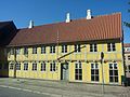 Studsgade 35, one of 4 listed buildings
 -
 Snevringen


References
- ^ "Studsgade" (in Danish). Aarhus City Archives. Archived from the original on 24 February 2016. Retrieved 16 February 2016.
- ^ "Gade Studsgade" (in Danish). Aarhus Municipality. Archived from the original on 1 April 2016. Retrieved 16 February 2016.
- ^ "Studsgadesport" (in Danish). Aarhus State Archives. Archived from the original on 23 February 2016. Retrieved 16 February 2016.
- ^ "Studsgade 29" (in Danish). Danish Heritage Agency. Archived from the original on 23 February 2016. Retrieved 16 February 2016.
- ^ "Studsgade 31" (in Danish). Danish Heritage Agency. Archived from the original on 23 February 2016. Retrieved 16 February 2016.
- ^ "Studsgade 35" (in Danish). Danish Heritage Agency. Archived from the original on 23 February 2016. Retrieved 16 February 2016.
- ^ "Studsgade 33" (in Danish). Danish Heritage Agency. Archived from the original on 23 February 2016. Retrieved 16 February 2016.
External links
- "Fredede Bygninger Marts 2018" [Listed Buildings March 2018] (PDF) (in Danish). Danish Agency for Culture and Palaces. Archived (PDF) from the original on 3 March 2018. Retrieved 3 March 2018.
Wikimedia Commons has media related to Studsgade.
- v
- t
- e
City of Aarhus
The Midtown boroughs: Indre By, Docklands, Frederiksbjerg, Langenæs, Marselisborg, Nørre Stenbro, Trøjborg, Vesterbro

- Ballehage Beach
- Botanical Gardens
- City Hall Park
- Concert Hall Park
- Forestry Botanical Garden
- Den Permanente
- Hasle Hills
- Langenæs Park
- Marselisborg Deer Park
- Marselisborg Forests
- Marselisborg Hospitals Park
- Marienlyst Park
- Mindeparken
- Mølleparken
- Nordre Cemetery
- Riis Forest
- Skanseparken
- Skjoldhøjkilen
- Skæring Hede
- St. Olufs Cemetery
- Tangkrogen
- Vennelystparken
- Vestereng
- Vestre Cemetery
- University Park
- Åkrogen
- Åparken
- Aarhus Cathedral
- Aarhus Methodist Church
- Åby Church
- Åbyhøj Church
- Brabrand Church
- Catholic Church of Our Lady
- Christian's Church
- Church of Our Lady
- Egå Church
- Ellevang Church
- Fredens Church
- Frederik's Church
- Hasle Church
- Holme Church
- Langenæs Church
- Lyseng Church
- Møllevang Church
- Ravnsbjerg Church
- Risskov Church
- St. John's Church
- St. Luke's Church
- St. Mark's Church
- St. Nicholas' Church
- St. Paul's Church
- Tilst Church
- Tranbjerg Church
- Skejby Church
- Vejlby Church
- Viby Church
- Aarhus University
- Aarhus School of Architecture
- Aarhus School of Marine and Technical Engineering
- Business Academy Aarhus
- School of Media and Journalism
- Central Library
- Deaconal Folk High School
- Jutland Art Academy'
- KaosPilot
- Ole Rømer Observatory
- Royal Academy of Music, Aarhus/Aalborg
- State and University Library
- VIA University College
 Category


56°09′35″N 10°12′39″E / 56.1598°N 10.2109°E / 56.1598; 10.2109


