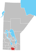
Rural Municipality of Rhineland
The Rural Municipality of Rhineland is a former rural municipality (RM) in the Canadian province of Manitoba. Since 1876, the area made up part of the Mennonite West Reserve. The R.M. of Rhineland was originally incorporated as a rural municipality on February 14, 1880 and later absorbed the neighbouring RM of Douglas in January 1891.[1] It ceased on January 1, 2015 as a result of its provincially mandated amalgamation with the towns of Gretna and Plum Coulee to form the Municipality of Rhineland.[2]
The RM was located in the southern part of the province, along its border with the state of North Dakota in the United States. It had a population of 4,125 persons in the 2006 census, a slight decrease from the 4,183 reported in the 2001 Census. There is a national historic site in the former RM's territory at Neubergthal, which was officially designated in 1998 as Neubergthal Street Village.
Geography
According to Statistics Canada, the former RM had an area of 953.42 km2 (386.12 sq mi).
Communities
- Blumenort
- Gnadenfeld
- Gnadenthal
- Halbstadt
- Horndean
- Kronsthal
- Neubergthal
- Neuhorst
- Rosenfeld
- Rosengart
- Rosetown
- Schoenwiese
- Sommerfeld
Adjacent municipalities
- Rural Municipality of Stanley - (west)
- Rural Municipality of Roland - (northwest)
- Rural Municipality of Morris - (northeast)
- Rural Municipality of Montcalm - (east)
- Pembina County, North Dakota - (south)
References
- ^ "Manitoba's Municipal History: Rural Municipalities and Local Government Districts". The Manitoba Historical Society. September 21, 2014. Retrieved January 2, 2015.
- ^ "Manitoba's Municipal History: Municipal Amalgamations (2015)". The Manitoba Historical Society. December 1, 2014. Retrieved January 2, 2015.
- Manitoba Historical Society - Rural Municipality of Rhineland
- Map of Rhineland R.M. at Statcan
- Manitoba Historical Society - Neubergthal Mennonite Street Village
- Neubergthal Mennonite Street Village
External links
- Official website
- The Rural Municipality of Rhineland
49°07′59″N 97°35′39″W / 49.13306°N 97.59417°W / 49.13306; -97.59417
 | This Manitoba location article is a stub. You can help Wikipedia by expanding it. |
- v
- t
- e


