Rural Municipality of Grandview
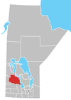
The Rural Municipality of Grandview is a former rural municipality (RM) in the Canadian province of Manitoba. It was originally incorporated as a rural municipality on June 1, 1901.[1] It ceased on January 1, 2015 as a result of its provincially mandated amalgamation with the Town of Grandview to form the Grandview Municipality.[2]
The Valley River 63A Indian reserve lied at the RM's west side, while part of Duck Mountain Provincial Forest occupied its northwestern sector, and part of Riding Mountain National Park occupied its southernmost sector.
Communities
- Meharry
References
- ^ "Manitoba's Municipal History: Rural Municipalities and Local Government Districts". The Manitoba Historical Society. September 21, 2014. Retrieved January 2, 2015.
- ^ "Manitoba's Municipal History: Municipal Amalgamations (2015)". The Manitoba Historical Society. December 1, 2014. Retrieved January 2, 2015.
External links
- Official website
- Map of Grandview R.M. at Statcan
- v
- t
- e
Division No. 17, Manitoba (Dauphin Area)
- Dauphin
| Former towns |
|
|---|
| Former villages |
|
|---|
| Former RMs |
|
|---|
- Ebb and Flow
- Keeseekoowenin (Partly)
- Alonsa
- Amaranth
- Ashville
- Bacon Ridge
- Bluff Creek
- Cayer
- East Bay
- Eddystone
- Fork River
- Freedale
- Garland
- Glencairn
- Halicz
- Harcus
- Keld
- Kinosota
- Laurier
- Lonely Lake
- Magnet
- Makinak
- Manitoba House
- Meharry
- Million
- Mink Creek
- Moore Dale
- Moose Bay
- Norgate
- North Junction
- Oak Brae
- Ochre River
- Paulson
- Portia
- Reedy Creek
- Reeve
- Reykjavik
- Rorketon
- Ste. Amélie
- Shergrove
- Sifton
- Silver Ridge
- Toutes Aides
- Trembowla
- Valley River
- Valpoy
- Venlaw
- Volga
- Weiden
- Zoria

 | This Manitoba location article is a stub. You can help Wikipedia by expanding it. |
- v
- t
- e
51°09′18″N 100°47′21″W / 51.15500°N 100.78917°W / 51.15500; -100.78917


