Il Capo Perpetua è un promontorio boschivo statunitense situato sulla costa centrale dell'Oregon nella contea di Lincoln che si proietta nell'Oceano Pacifico. È gestito dallo United States Forest Service in quanto parte della Parco nazionale di Siuslaw.
Ubicazione
Il Capo Perpetua è ubicato a circa 3,2 Km a sud di Yachats lungo l'autostrada U.S. Route 101. È un tipico promontorio del Pacifico nord-occidentale che forma un'alta e ripida scogliera sull'oceano. Nel suo punto più alto si erge di 240 m sopra il livello del mare con la possibilità, in una giornata di cielo sereno, di vedere la costa per 110 km e l'orizzonte marino fino a 60 km di distanza[1].
Storia
Per almeno 6000 anni i nativi americani del luogo si sono nutriti di molluschi, granchi, ricci di mare e vongole lungo la costa vicino a Capo Perpetua. Il promontorio rientrava nella parte meridionale del territorio abitato dagli Alsea: nella loro lingua era chiamato Halqaik che significava pressappoco luogo esposto. Le prove della loro presenza sono rappresentate dagli enormi accumuli di conchiglie che si incontrano lungo le rive del Cape Perpetua Visitor Center[1][2][3].
Il promontorio deve il suo nome al capitano James Cook che lo scoprì il 7 marzo 1778, giorno in cui si celebra Santa Perpetua, mentre cercava l'ingresso nel Pacifico attraverso il passaggio a nord-ovest[4].
La zona fa parte del Parco nazionale di Siuslaw dal 1908. Nel 1914 lo United States Forest Service scavò una stradina nella scogliera del Capo Perpetua e costruì un ponte di legno sul fiume Yachats, favorendo la comunicazione tra le piccole comunità di Yachats e Florence verso sud. Il ponte di legno è stato sostituito nel 1926 con una struttura in acciaio. Il tratto dell'autostrada Roosevelt Memorial Highway, oggi U.S. Route 101, che attraversa Capo Perpetua è stato completato negli anni trenta[2][4].
Nel 1933 è stato costruito un accampamento dei Civilian Conservation Corps (CCC) ai piedi del promontorio a nord di Capo Creek vicino all'attuale Cape Perpetua Visitor Center. I CCC hanno costruito l'accampamento[5], una rete di sentieri e il posto di vedetta West Shelter sulla cima del promontorio. Durante la seconda guerra mondiale la West Shelter è stata utilizzata come stazione di guardia con la temporanea installazione di un grande cannone di difesa costiera[1][4][6]. Fu anche installato un radar SCR-270B in un luogo non specificato per sfruttare l'altezza del promontorio[7].
Il Cape Perpetua Shelter and Parapet è nell'elenco del National Register of Historic Places dal 1989[8].
Note
- ^ a b c Cape Perpetua Scenic Area, USDA Forest Service, Siuslaw National Forest,
- ^ a b Sullivan, William L., Hiking Oregon's History, Navillus Press, Eugene, Oregon, 2000.
- ^ Cape Perpetua
- ^ a b c "Yachats History"
- ^ Facility Details - CAPE PERPETUA, OR, su recreation.gov. URL consultato il 28 aprile 2014.
- ^ "The CCC Camp at Cape Perpetua" Archiviato il 27 ottobre 2017 in Internet Archive., Yachats Area Chamber of Commerce, Yachats, Oregon, 2008.
- ^ B. Lewis, World War II Mystery Solved, in Oregon Coast Magazine, Northwest Magazines, February 2009.
- ^ National Register Digital Assets
Voci correlate
Altri progetti
 Wikimedia Commons contiene immagini o altri file su Capo Perpetua
Collegamenti esterni
- Cape Perpetua Visitor Center
- Siuslaw National Forest
 Aree naturali protette in Oregon Aree naturali protette in Oregon  |
|---|
| Federale | | National Park Service | | Parchi nazionali | Crater Lake |
|---|
Parchi e siti
storici nazionali | Fort Vancouver · Lewis and Clark · Nez Perce |
|---|
| Monumento nazionale | John Day Fossil Beds · Monumento nazionale vulcanico di Newberry (USFS) · Oregon Caves |
|---|
|
|---|
| United States Forest Service | |
|---|
| National Wildlife Refuge | Ankeny · Bandon Marsh · Baskett Slough · Bear Valley · Cape Meares · Cold Springs · Deer Flat · Hart Mountain · Klamath Marsh · Lewis and Clark · Lower Klamath · Malheur · McKay Creek · Nestucca Bay · Oregon Islands · Rifugio Julia Butler Hansen per il cervo colombiano dalla coda bianca · Siletz Bay · Three Arch Rocks · Tualatin River · Umatilla · Upper Klamath · Wapato Lake · William L. Finley |
|---|
| Zone selvagge | Badger Creek · Black Canyon · Boulder Creek · Bridge Creek · Bull of the Woods · Clackamas · Copper Salmon · Cummins Creek · Diamond Peak · Drift Creek · Eagle Cap · Gearhart Mountain · Grassy Knob · Hells Canyon · Kalmiopsis · Lower White River · Mark O. Hatfield · Menagerie · Middle Santiam · Mill Creek · Monument Rock · Mount Hood · Mount Jefferson · Mount Thielsen · Mount Washington · Mountain Lakes · North Fork John Day · North Fork Umatilla · Opal Creek · Oregon Badlands · Oregon Islands · Red Buttes · Roaring River · Rock Creek · Rogue–Umpqua Divide · Salmon–Huckleberry · Sky Lakes · Soda Mountain · Spring Basin · Steens Mountain · Strawberry Mountain · Table Rock · Three Arch Rocks · Three Sisters · Waldo Lake · Wenaha–Tucannon · Wild Rogue |
|---|
Sistema nazionale di
conservazione del paesaggio | Monumento nazionale di Cascade–Siskiyou · Steens Mountain · Yaquina Head |
|---|
| Altre aree protette | Area di ricerca naturale di Lost Forest · Cascade Head · Christmas Valley Sand Dunes · Fossil Lake · Riserva nazionale di ricerca sugli estuari di South Slough · Upper and Lower Table Rock · Wildwood Recreation Site |
|---|
|
|---|
| Statale | | Parchi statali | | North Coast | Arcadia Beach · Bob Straub · Bradley · Cape Kiwanda · Cape Lookout · Cape Meares · Clay Myers at Whalen Island · Del Rey Beach · Ecola · Elmer Feldenheimer · Fishing Rock · Fort Stevens · Gearhart Ocean · Haystack Hill · Hug Point · John Yeon · Manhattan Beach · Munson Creek Falls · Neahkahnie–Manzanita · Nehalem Bay · Oceanside Beach · Oswald West · Rockaway Beach · Sunset Beach · Sunset Highway Forest · Symons · Tolovana Beach · Tolovana Beach · Twin Rocks · Wilson River Highway Forest |
|---|
| Central Coast | Agate Beach · Alsea Bay · Beachside · Beaver Creek · Beverly Beach · Boiler Bay · Carl G. Washburne · Collins Creek · D River · Darlingtonia · Devils Lake · Devils Punch Bowl · Driftwood Beach · Ellmaker · Fogarty Creek · Gleneden Beach · Governor Patterson · H.B. Van Duzer · Heceta Head Lighthouse · Jessie M. Honeyman · Joaquin Miller Forest · L. Presley & Vera C. Gill · Lost Creek · Muriel O. Ponsler · Neptune · Neskowin Beach · Ona Beach · Otter Crest · Pritchard · Roads End · Rocky Creek · San Marine · Seal Rock · Smelt Sands · South Beach · Stonefield Beach · Tokatee Klootchman · W. B. Nelson · Whale Watching · Yachats · Yachats Ocean Road · Yaquina Bay |
|---|
| South Coast | Albert H. Powers · Alfred A. Loeb · Arizona Beach · Bandon · Bolon Island Tideways · Buena Vista Ocean State Wayside · Bullards Beach · Cape Arago · Cape Blanco · Cape Sebastian · Conde B. McCullough · Coquille Myrtle Grove · Crissey Field · Elk Creek Tunnel Forest · Face Rock · Floras Lake · Geisel Monument · Golden and Silver Falls · Harris Beach · Hoffman · Humbug Mountain · Hutchinson · Lone Ranch · Maria C. Jackson · McVay Rock · Ophir · Otter Point · Paradise Point · Pistol River · Port Orford Cedar Forest · Port Orford Heads · Samuel H. Boardman · Seven Devils · Shore Acres · Sisters Rock · Sunset Bay · Sweet Myrtle · Umpqua · Umpqua Lighthouse · Umpqua Myrtle · William M. Tugman · Winchuck · Yoakam Point |
|---|
Portland
Metro | Banks–Vernonia · Bonnie Lure · Government Island · L. L. "Stub" Stewart · Mary S. Young · Milo McIver · Tryon Creek · Willamette Stone |
|---|
Gola del
Columbia /
Monte Hood | Ainsworth · Benson · Bonneville · Bridal Veil Falls · Crown Point · Dabney · Dalton Point · George W. Joseph · Guy W. Talbot · Historic Columbia River Highway · John B. Yeon · Koberg Beach · Lang Forest · Lewis and Clark · Lindsey Creek · Mayer · McLoughlin · Memaloose · Multnomah Falls · Portland Women's Forum · Rocky Butte · Rooster Rock · Seneca Fouts · Shepperd's Dell · Sheridan · Starvation Creek · Viento · Vinzenz Lausmann · Wyeth · Wygant |
|---|
Willamette
Valley | Alderwood · Bald Peak · Blachly Mountain Forest · Bowers Rock · Campidoglio · Cascadia · Detroit Lake · Dexter · Elijah Bristow · Erratic Rock · Fall Creek · Fort Yamhill · Holman · Jasper · Lowell · Luckiamute · Maples · Maud Williamson · Molalla River · North Santiam · Sarah Helmick · Silver Falls · State Capitol · Thompson's Mills · Washburne · Willamette Mission |
|---|
Oregon
meridionale | Ben Hur Lampman · Canyon Creek Forest · Casey · Collier Memorial · Illinois River Forks · Jackson F. Kimball · Joseph H. Stewart · Klamath Falls – Lakeview Forest · OC&E Woods Line · Prospect · Rough and Ready Forest · Stage Coach Forest · TouVelle · Tub Springs · Valley of the Rogue · Wolf Creek Inn |
|---|
Oregon
centrale | Cline Falls · Cottonwood Canyon · Deschutes River · Dyer · Elliott Corbett · La Pine · Ochoco · Peter Skene Ogden · Pilot Butte · Prineville Reservoir · Redmond–Bend Juniper · Sisters · Smith Rock · The Cove Palisades · Tumalo · White River Falls |
|---|
Oregon
orientale | Bates · Battle Mountain Forest · Blue Mountain Forest · Booth · Catherine Creek · Chandler · Clyde Holliday · Crooked Creek · Deadman's Pass · Emigrant Springs · Farewell Bend · Fort Rock · Fort Rock Cave · Frenchglen Hotel · Goose Lake · Hat Rock · Hilgard Junction · Kam Wah Chung · Lake Owyhee · Minam · Ontario · Pete French Round Barn · Red Bridge · Succor Creek · Sumpter Valley Dredge · Ukiah–Dale Forest · Unity Forest · Unity Lake · Wallowa Lake · Wallowa Lake Highway Forest · Wallowa River · Cougar Valley · Garrison Lake · Golden · Kendall Bar · Siuslaw Dunes |
|---|
|
|---|
| Foreste statali | Clatsop · Elliott · Gilchrist · Santiam · Sun Pass · Tillamook |
|---|
| Aree naturali statali | Bridge Creek · Dean Creek · Denman · E. E. Wilson · Elkhorn · Fern Ridge · Irrigon · Jewell Meadows · Klamath · Ladd Marsh · Lower Deschutes · Phillip W. Schneider · Prineville · Riverside · Sauvie Island · Snake River Islands · Summer Lake · Wenaha · White River · Willow Creek |
|---|
|
|---|
| Locale | | Metro | Blue Lake · Cooper Mountain · Glendoveer · Graham Oaks · Howell · Oregon Zoo · Oxbow · Smith and Bybee · Mount Talbert |
|---|
| Portland | Arboreto di Hoyt · Area naturale di Tideman Johnsona · Audubon Society of Portland · Butterfly Park · Crystal Springs Rhododendron Garden · Forest Park · Oaks Bottom Wildlife Refuge · Parco naturale di Powell Butte · Washington Park |
|---|
Tualatin Hills Park &
Recreation District | Parco naturale di Tualatin Hills |
|---|
|
|---|
| Registri patrimoniali: Registro nazionale dei luoghi storici · Punti di riferimento storici nazionali · Punto di riferimento naturale nazionale · Rete mondiale di riserve della biosfera |
|---|
| Controllo di autorità | VIAF (EN) 315530317 · LCCN (EN) sh91000933 · J9U (EN, HE) 987007548978105171 |
|---|
 Portale Ecologia
 Portale Stati Uniti d'America
 Stati Uniti
  Oregon

 La Devil's Churn (Insenatura del Diavolo) vicino a Capo Perpetua.
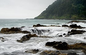 Il pozzo di Thor.
 La vedetta West Shelter.


 Aree naturali protette in Oregon
 Portale Ecologia
 Portale Stati Uniti d'America


